Leading Provider of Ecology Services in Greater London

Biodiversity Habitat Surveys and Ecological Assessments
Redwood Integrity Group Ltd provides technology-led support for biodiversity habitat surveys and ecological assessments across Greater London. Using drones and aerial imaging allows detailed information to be gathered across habitats, development sites and other environments where a wider view of existing conditions can be valuable.
Drone surveys can capture high-resolution imagery across large areas, helping to document habitats and environmental features efficiently. Aerial data can also provide useful context for ecology professionals undertaking wider assessments, monitoring changes or planning further investigations.
This approach can be particularly valuable where sites contain difficult terrain, restricted access or areas where unnecessary physical disturbance should be minimised. Aerial photography provides a clear visual record that can be reviewed following the survey and incorporated into wider environmental project information.
Our ecology survey support can include:
- Biodiversity habitat survey support
- Ecological assessment data
- Habitat mapping
- High-resolution aerial photography
- Drone surveys
- Site inspections
- Environmental monitoring
- Aerial mapping
- Photogrammetry
- 3D mapping
Survey requirements can vary considerably depending on the environment and purpose of the project. We therefore focus on capturing information appropriate to the site and the objectives of the ecology professionals involved.
Our wider capabilities in land surveying, topographic survey support and aerial mapping can also help provide spatial information about the surrounding environment.
For projects in Greater London and Cambridgeshire, Redwood Integrity Group Ltd provides practical aerial survey support designed to complement ecological expertise and provide clear information for environmental decision-making.

Thermal Surveys and Wildlife Conservation
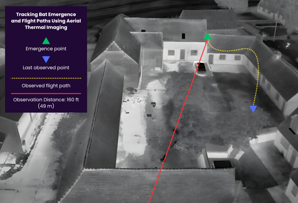
Thermal technology provides another useful method of gathering information for certain ecology and wildlife conservation projects. Rather than relying exclusively on visible imagery, thermal surveys identify variations in temperature, which can help detect heat signatures in suitable survey conditions.
Redwood Integrity Group Ltd can combine thermal imaging with drone technology to gather aerial information across habitats and other locations. This approach can provide an additional perspective for ecology professionals undertaking wildlife monitoring or environmental investigations.
Drone-based thermal surveys can be useful where animals or features may be difficult to observe from ground level. They can also allow larger areas to be examined efficiently while reducing the need for extensive access through sensitive environments.
Our thermal and wildlife survey support can include:
- Aerial thermal surveys
- Wildlife monitoring support
- Habitat observations
- Drone-based thermal imaging
- Visual aerial photography
- Site inspections
- Environmental survey data
- Wildlife conservation project support
- Mapping of survey areas
- High resolution imagery
Thermal survey results should be considered alongside appropriate ecological expertise and other relevant assessment methods. Our role is to provide clear aerial and thermal information that can support the wider investigation.
The combination of visual and thermal data can also make it easier to compare observations and identify areas where additional investigation may be appropriate.
By tailoring the technology and survey approach to the environment, Redwood Integrity Group Ltd can provide useful information for wildlife conservation, biodiversity projects and ecological assessments across Greater London and Cambridgeshire.
Drone Surveys, Aerial Mapping and Environmental Consultancy Support
Drone technology provides an efficient way of gathering detailed information across land, habitats, buildings and development sites. Our Ecology Services in Greater London can incorporate drone surveys and aerial mapping to support ecology professionals and wider environmental consultancy projects.
High-resolution aerial photography can provide an overview of a site while capturing individual features in greater detail. Depending on project requirements, imagery can also be processed using photogrammetry to produce mapping information and 3D representations of the surveyed environment.
These capabilities are useful where environmental projects require accurate visual records, repeat surveys or information about changes taking place across a site.
Our drone and environmental survey services can include:
- Drone surveys
- Aerial mapping
- Aerial photography
- Site inspections
- 3D mapping
- Photogrammetry
- Land surveying support
- Topographic survey support
- Construction monitoring
- Habitat mapping
- Environmental site documentation
Our wider surveying capabilities also allow us to support projects involving the built environment. These services include roof inspections, building surveys, condition surveys, defect inspections and property condition information where environmental and property requirements form part of the same wider project.
Construction monitoring can also provide repeatable aerial records during development, helping project teams understand how sites change over time.
Redwood Integrity Group Ltd provides survey information that is intended to be practical, clear and relevant to the project. By combining aerial imagery, mapping and modern survey technology, we can support ecology and environmental professionals working throughout Greater London and Cambridgeshire.
Get in Touch
Contact Redwood Integrity Group Ltd to discuss Ecology Services in Greater London. We can provide drone surveys, biodiversity habitat survey support, thermal imaging, aerial mapping and environmental survey data tailored to your project.